Evidence and Examples of Earth Changes Throughout History. The Truth Behind The Scenes. Excerpts:
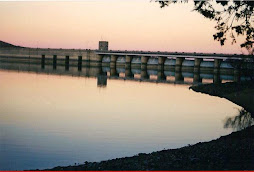
Satellite images have revealed that a network of ancient rivers once flowed through the sands of the Arabian Desert, leading scientists to believe that the region experienced wetter periods in the past.
The images are the starting point for a major potentially ground-breaking research project led by the University of Oxford into human evolutionary heritage. The research team will look at how long-term climate change affected early humans and animals who settled or passed through and what responses determined whether they were able to survive or died out.
Until now this part of the world has been largely ignored by scholars despite its critical location as a bridge between Africa and Eurasia. In a project funded by the ERC (European Research Council), a multidisciplinary team of researchers will study the effects of environmental change in the Arabian Peninsula over the last two million years. The systematic study of the Pleistocene to Holocene periods will be unique in its length and level of detail.
Over the course of five years the researchers will study the landscape features and excavate sites of likely archaeological interest, using the network of water courses as a map. They will use the latest dating techniques to pinpoint the ages of fossils of animals, plants and different stone tool technologies and compare the similarities and differences displayed in the region’s rock art.
The team’s main focus will be the Arabian Desert, but the work will also cover the wider Peninsula. One key question they will attempt to answer is when the first early modern humans are likely to have first arrived in the Arabian Peninsula from Africa and perhaps surrounding regions. They will also look for evidence that suggests how early modern humans were able to survive, or not, in arid and extreme conditions.
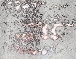
Project leader Professor Michael Petraglia, Co-Director of the Centre for Asian Archaeology at Oxford University’s School of Archaeology, said: ‘From NASA images (above) taken of the Arabian Desert we can see physical landscape features that are visible from space that denote a whole network of former river valleys and lake basins. These lines and dips in the sand provide us with a map of the region upon which we will focus our research activity. The presence of water is an accurate indicator of where early humans and animals migrated to or settled.
Given enough time, a completely, radically different understanding of Earth's physical history will develop. It's happening now, and when unified, will be awesome. Not now, but soon. Tomorrow's Started..
Satellite images have revealed that a network of ancient rivers once flowed through the sands of the Arabian Desert, leading scientists to believe that the region experienced wetter periods in the past.
The images are the starting point for a major potentially ground-breaking research project led by the University of Oxford into human evolutionary heritage. The research team will look at how long-term climate change affected early humans and animals who settled or passed through and what responses determined whether they were able to survive or died out.
Until now this part of the world has been largely ignored by scholars despite its critical location as a bridge between Africa and Eurasia. In a project funded by the ERC (European Research Council), a multidisciplinary team of researchers will study the effects of environmental change in the Arabian Peninsula over the last two million years. The systematic study of the Pleistocene to Holocene periods will be unique in its length and level of detail.
Over the course of five years the researchers will study the landscape features and excavate sites of likely archaeological interest, using the network of water courses as a map. They will use the latest dating techniques to pinpoint the ages of fossils of animals, plants and different stone tool technologies and compare the similarities and differences displayed in the region’s rock art.
The team’s main focus will be the Arabian Desert, but the work will also cover the wider Peninsula. One key question they will attempt to answer is when the first early modern humans are likely to have first arrived in the Arabian Peninsula from Africa and perhaps surrounding regions. They will also look for evidence that suggests how early modern humans were able to survive, or not, in arid and extreme conditions.
Project leader Professor Michael Petraglia, Co-Director of the Centre for Asian Archaeology at Oxford University’s School of Archaeology, said: ‘From NASA images (above) taken of the Arabian Desert we can see physical landscape features that are visible from space that denote a whole network of former river valleys and lake basins. These lines and dips in the sand provide us with a map of the region upon which we will focus our research activity. The presence of water is an accurate indicator of where early humans and animals migrated to or settled.
Given enough time, a completely, radically different understanding of Earth's physical history will develop. It's happening now, and when unified, will be awesome. Not now, but soon. Tomorrow's Started..


No comments:
Post a Comment